Gamma irradiation technology
- The gamma irradiation process uses Cobalt 60 radiation to kill microorganisms on a variety of different products in a specially designed cell.
- Gamma radiation is generated by the decay of the radioisotope Cobalt 60, with the resultant high energy photons being an effective sterilant.
- Gamma irradiation technology is used for inhibition of sprouting in bulbs and tubers, insect disinfestation of cereals, pulses and grains, microbial decontamination (hygienization) of dry spices etc. for preservation/shelf life extension by applying pre-determined radiation doses.
- Setting of food irradiation facilities in the PPP mode certainly mitigates the huge quantum of post-harvest and storage losses of agricultural produce and food that results in national saving. However, reduction of food wastage will depend on various aspects such as post irradiation storage, total quantity of irradiated food products and time lapse between irradiation and distribution to users.
- The following reforms related to Atomic Energy proposed
- Establishing Research Reactor in PPP mode for production of medical isotopes to promote welfare of humanity through affordable treatment for cancer and other diseases.
- Establishing Facilities in PPP mode to use irradiation technology for food preservation.
- Linking India’s robust start-up ecosystem to nuclear sector by setting up Technology Development-cum-Incubation Centres for fostering synergy between research facilities and tech-entrepreneurs.
PBI
High-Tech measures for improvement in Aviation
- The Government has and will continue to undertake hi-tech measures for improvement in civil aviation sector in the country, some of which are as follows:
- The policy on Digi Yatra has been released by the Ministry of Civil Aviation in August 2018. This initiative aims to provide a contactless, seamless and paperless handling of passengers at airports from the entry gate of the terminal to the boarding point.
- Modernisation of air navigation infrastructure has been taken up.
- Route rationalization in the Indian airspace is being carried out in coordination with Indian Air Force, using modern air traffic flow management techniques to develop shorter flight routes and lower fuel consumption by airlines.
- Greater use of digital technology is being encouraged at air cargo terminals to enhance efficiency and to reduce dwell times.
- E-Governance is being enabled at Directorate General of Civil Aviation (DGCA) and Bureau of Civil Aviation Security (BCAS) for most of their stakeholder interactions and internal processes.
PBI
Steps taken by the government to develop educational institutions of global standards
- The Government of India is committed to empower the higher educational institutions in the country to achieve global standards. In this context, the World Class Institutions Scheme was launched in the year 2017 to enable ten institutions each from the public and private category to have world class academic & research facilities and grant them the status of Institution of Eminence (IoE).
- So far, twelve institutions (08 public & 04 private) have been approved under the scheme.
- Significant amount of autonomy in academic, administrative & financial matters has been provided under the regulatory framework to these institutions so that they can emerge as global educational institutions.
- The Government is providing financial assistance of upto Rs. 1000 Crore each (over a period of five years) to public Institutions of Eminence
- The scheme envisions the selected institutions to feature in top 500 of the global educational institutions in a period of ten years after selection as IoE and improve to get into the list of top 100 global institutions eventually in any of the world renowned ranking frameworks.
Steps taken by the government to provide online education to students
- A comprehensive initiative called PM eVIDYAhas been initiatedas part of AtmaNirbhar Bharat Abhiyaan on 17th May, 2020, which unifies all efforts related to digital/online/on-air education to enable multi-mode access to education. The initiative includes:
- DIKSHA (one nation, one digital platform)is the nation’s digital infrastructure for providing quality e-content for school education in states/UTs and QR coded Energized Textbooks for all gradesare available on it.
- One earmarked SwayamPrabha TV channel per class from 1 to 12 (one class, one channel).
- Extensive use of Radio, Community radio and CBSE Podcast- ShikshaVani.
- Special e-content for visually and hearing impaired developed on Digitally Accessible Information System (DAISY) and in sign language on NIOS website/ YouTube
- Also, to reach out to those students who lack access to technology various innovative activities are being done at national, state or district level such as Gali-GaliSim-Sim, Tili-Mili programme, Motor Eskool, Roving Teacher, Project SMILE (Social Media Interface for Learning Engagement), e-Kaksha, formation of Whatsap and other social media groups, Work Book Distribution at home, Teacher calling to maintain connects with students.
- School Education is in the Concurrent List of the Constitution and the state governments have been directed to act based on the situation prevailing at every place to meet the demands of all students for providing them with the digital access required for learning digitally.
- Depending on the states’ requirement the Ministry of Education provides Rs.6.40 Lakh for setting up computer labs and Rs.2.40 Lakh for smart classroom
Assam -Mizoram conflict


- The 164.6 km long border that runs between the two states has again become a flashpoint in the recent years, with several instances of violence being reported in the region.
- The conflict-ridden history of this tenuous border, lined by the Barak Valley – Cachar, Hailakandi, and Karimganj on the Assam side, and Kolasib, Aizawl, and Mamit on the Mizoram side, dates back to the Colonial era.
- A notification issued by the British administration in 1875 had, for the first time, stipulated a clear demarcation between the Cachar plains (which lie in present-day Assam) and Lushai Hills, which later came to be known as Mizoram.
- In 1933, another notification released by the British government, marked the separation between the Lushai Hills and Manipur, which indicated that the Manipur border began from the tripoint of Lushai Hills, Assam’s Cachar district and Manipur.
- Mizoram, which broke off from Assam in 1972 to become a Union Territory and went on to attain full statehood in 1987, follows the 1875 notification, claiming that it is the only prescription that took into account the position of the Mizo community.
- Almost one and a half centuries ago and 17 years before the Lushai hills was annexed to British Assam in 1892, the ‘inner line’ boundary of the Lushai hills was ‘fixed’ in 1875 on the southern border of Assam’s Cachar district.
- In line with the colonial practice of ‘fixing’ borders, this boundary was however not ‘precise’ as it was drawn largely using natural markers such as rivers and hills.
- In post-independent India, the Mizoram government has accepted this boundary in preference over the subsequent revisions made by the colonial government when the Inner Line Permit under the Bengal Eastern Frontier Regulation, 1873 was extended to the Lushai hills district in 1930 and 1933.
- Unlike the 1875 boundary, which involved a proxy of Suakpuilala, one of the Lushai chiefs, the Mizoram government perceives that the boundary instituted by these revisions sidestepped them and amounted to unilateral superimposition — driven as it were by ‘administrative convenience’.
- These revisions are also seen to conspicuously fail to recognise the Mizo’s long-standing historical rights to use the un-demarcated southern border of Cachar as their hunting ground, for jhum cultivation, and as sites of their resource extraction including rubber and timber.
- The enclosure of about 509 square miles of the Lushai hills under the Inner Line Reserve Forest area via the Assam Forest Regulation, 1877, is being cited as one of the glaring exemplars of ‘encroachment’ by the Assam government into the Lushai hills (now Mizoram).
- However, considering that borders cannot be driven by perception but by institutionalised rules and laws, Assam’s government continues to refuse to accept Mizoram’s standpoint
- Seen from this standpoint, the Assam government considers Mizo plantation and settlements in the Inner Line Reserve Forest areas as an ‘encroachment’.
- The discovery of oil, tea, rubber and coal around the middle of the 19th century in the ‘outer limits’ of Assam proper and the concomitant attempt to commercialise these commodities impel the regulation of trade and commerce between the British and their competitors.
- The enclosure of land in these ‘outer limits’ by declaring them either as ‘forest reserve areas’ or imposing an inner line permit raj system stem from this. This development leverages a new land-use regime which is principally driven by efforts to augment State revenues.
- One of the unintended consequences was the large-scale migration of labour from various parts of British India into Cachar, Hailakandi, and Karimganj.
- The recent overtures by Mr. Sarma to approach the Supreme Court of India, and raise a 4,000- strong commando battalion to ‘protect’ the ‘forest reserve’ areas need to be seen against this backdrop
- Mizoram government advocate a ‘people-centric’ approach which seeks to give a premium to the historical and traditional rights of the local indigenous people on the one hand and to the principle of uti possidetis juris (‘as you possess under law’, including customary law)
India and Nepal flood management
- Infrastructure augmentation for dams and reservoirs, detention basins, embankments and channel improvement. Non-structural measures were also adopted in later years such as floodplain management, flood forecasting and warning, flood insurance and financial compensation
- a solution to the issue of chronic flooding lies in revisiting the old plans and arrangements between India and Nepal.
- This is because flood control in Bihar is just not possible till a dedicated intergovernmental panel is formed through a bilateral mechanism between India and Nepal
- About 68,800 sq. km out of a total geographical area of 94,163 sq. km, or about 73.06% of the land area is flood affected.
- A large part of north Bihar, adjoining Nepal, is drained by a number of rivers that have their catchments in the steep and geologically nascent Himalayas.
- Originating in Nepal, the high discharge and sediment load in the Kosi, Gandak, Burhi Gandak, Bagmati, Kamla Balan, Mahananda and Adhwara Group wreak havoc in the plains of Nepal’s Tarai and Bihar.
- “About 65% of the catchment area of these rivers falls in Nepal/Tibet and only 35% of the catchment area lies in Bihar
- work on the Kosi embankments started in January 1955, a group of retired Nepali soldiers came over voluntarily to join hands with Indian volunteers and start the work
- The Kosi Treaty of 1954, under which the embankments in Nepal were established and maintained, was not futuristic and did not make enough provisions for the maintenance of embankments and the rivers changing their course.
- The deposition of stones, sand, silt and sediment has led to river beds rising, changing course and causing unimaginable losses
- there is a need for greater sensitisation on climatic imbalances and sustainable development.
- Ironically, the same flood-affected regions also face the issue of drought and a sinking water table.
- With a long-term strategy of water management cooperation between India and Nepal, the matter should be looked into.
Online gambling
- The Tamil Nadu government’s effort to protect its youth from the temptations of online gambling by amending a colonial gaming law to ban online rummy and poker, has not survived judicial scrutiny.
- Its amendment to the Tamil Nadu Gaming Act, 1930, has been struck down by the Madras High Court, which found the prohibition unreasonable because it sought to bring even games predominantly of skill under the label of gambling, if there was an element of betting or even prize money or any other stake involved.
- The State’s intention was acceptable to the extent that it sensed the danger involved in allowing addictive games
- it erred in failing to make a distinction between games of skill and games of chance, and in seeking to treat as ‘gaming’ anything that involved stakes, contrary to judicial pronouncements circumscribing the term to games that are based on chance
- The court rightly found that this would actually render illegal even offline games that were played for prize money
Agalega island

- Mauritius has denied a report that it has allowed India to build a military base on the remote island of Agalega, with a government official telling AFP that no such agreement exists between the two nations.
- Earlier this week, news broadcaster Al Jazeera reported on the construction of an airstrip and two jetties to house an Indian military base on Agalega, located about 1,000 km north of the archipelago’s main island.
Chagos island
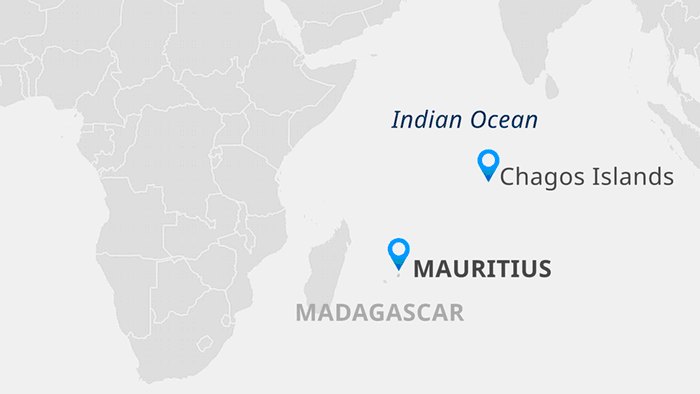
- Decision by Britain to separate the Chagos Islands from Mauritius and set up a joint military base with the United States on Diego Garcia, the largest of the isles.
- The decades-old move has sparked protests by Chagossians, who accused Britain of carrying out an “illegal occupation” and barring them from their homeland.
- Britain insists the islands belong to London and has renewed a lease agreement with the United States to use Diego Garcia until 2036.
- Diego Garcia played a strategic role during the Cold War, and then as an airbase, including during the war in Afghanistan.